
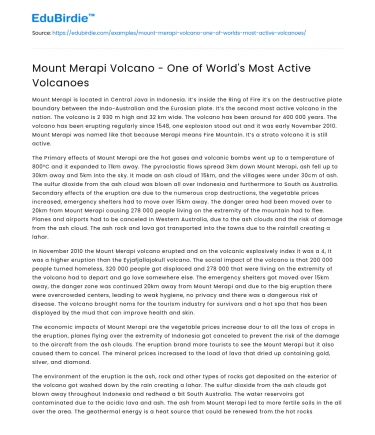
Introduction
Mount Merapi, located on the island of Java in Indonesia, is renowned as one of the most active volcanoes in the world. With eruptions occurring at least once every decade, it is a significant geological feature that commands both fear and respect. The volcano's name translates to "Mountain of Fire," a fitting description given its frequent activity and the fiery nature of its eruptions. Merapi's stratovolcano structure, characterized by steep profiles and periodic explosive eruptions, poses a constant threat to nearby densely populated regions, including the city of Yogyakarta. The volcano's activity is not only of local and regional concern but also attracts international attention, highlighting the need for comprehensive understanding and management of volcanic hazards. This essay explores Mount Merapi’s geological characteristics, historical eruptions, and the complex interplay between human resilience and disaster management efforts.
Geological Characteristics and Activity Patterns
Mount Merapi is a stratovolcano, a type of volcano known for its layered structure formed by successive layers of lava and ash. This geological feature results from the subduction of the Indo-Australian Plate beneath the Eurasian Plate, which contributes to Merapi's high level of activity. According to the United States Geological Survey, "Merapi is the most active volcano in Indonesia, with its last major eruption occurring in 2010" (USGS, 2011). The volcano's eruptions are typically of the Vulcanian type, characterized by explosive outbursts of ash and pyroclastic flows. These eruptions pose a significant hazard to the surrounding areas.

One of the defining characteristics of Mount Merapi's eruptions is the effusion of lava domes, which can collapse and generate pyroclastic flows. The 2006 eruption saw such an event, causing widespread devastation. These pyroclastic flows can travel at speeds exceeding 100 km/h, covering distances up to 15 kilometers from the crater, as noted by Surono, the former head of the Center for Volcanology and Geological Hazard Mitigation in Indonesia (Surono, 2010). The continuous monitoring and study of Merapi’s activity patterns are crucial for predicting future eruptions and mitigating their impact on human settlements.
Historical Eruptions and Impact on Human Populations
Mount Merapi's historical eruptions have had profound impacts on the surrounding human populations. The 2010 eruption was one of the largest in recent history, resulting in the evacuation of over 350,000 people and claiming the lives of 353 individuals (BNPB, 2011). This eruption was marked by large pyroclastic flows, widespread ashfall, and the destruction of infrastructure. The economic impact was substantial, affecting agriculture, housing, and tourism, which are vital sectors for the local economy.
Despite the risks, the fertile volcanic soil surrounding Merapi supports agriculture, leading to a paradox where people continue to live in its proximity. This risk-taking behavior underscores the complex relationship between humans and their environment. As noted by Donovan and others, "Volcanic hazards coexist with fertile land that supports a high population density, creating a classic risk-perception paradox" (Donovan et al., 2012). The resilience of these communities is evident in their ability to adapt to the ever-present threat of volcanic activity, though it also highlights the need for effective disaster management strategies.
Disaster Management and Community Resilience
The recurrent threat posed by Mount Merapi necessitates robust disaster management and community resilience strategies. The Indonesian government, along with international partners, has implemented various measures to mitigate the risks associated with future eruptions. The establishment of early warning systems and evacuation protocols are critical components of these efforts. Additionally, community-based disaster preparedness programs aim to empower local populations with the knowledge and tools needed to respond effectively to volcanic threats.
A study by Lavigne and colleagues highlights the importance of integrating scientific research with traditional knowledge to enhance community resilience (Lavigne et al., 2008). For example, local beliefs and practices regarding Merapi's activity are incorporated into official disaster management plans. This approach not only respects cultural heritage but also fosters trust and cooperation between authorities and communities. However, challenges remain in ensuring the sustainability of these initiatives, particularly in terms of funding and continuous engagement with the affected populations.
Conclusion
Mount Merapi stands as a formidable natural entity that continues to intrigue and challenge both scientists and local communities. Its frequent eruptions and the resultant hazards underscore the importance of ongoing geological research and effective disaster management. While the volcano presents a persistent threat, it also offers opportunities for advancing our understanding of volcanic activity and improving resilience measures. The delicate balance between harnessing the benefits of fertile volcanic soils and safeguarding human lives necessitates a nuanced approach that integrates scientific, cultural, and practical considerations. Ultimately, the story of Mount Merapi is one of resilience and adaptation, reflecting the indomitable human spirit in the face of nature's unpredictability.
Did you like this example?
Yes
No

Cite this paper
Mount Merapi: An Ever-Restless Giant.
(2022, September 15). Edubirdie. Retrieved March 3, 2026, from https://hub.edubirdie.com/examples/mount-merapi-volcano-one-of-worlds-most-active-volcanoes/
“Mount Merapi: An Ever-Restless Giant.” Edubirdie, 15 Sept. 2022, hub.edubirdie.com/examples/mount-merapi-volcano-one-of-worlds-most-active-volcanoes/
Mount Merapi: An Ever-Restless Giant. [online].
Available at: <https://hub.edubirdie.com/examples/mount-merapi-volcano-one-of-worlds-most-active-volcanoes/> [Accessed 3 Mar. 2026].
Mount Merapi: An Ever-Restless Giant [Internet]. Edubirdie.
2022 Sept 15 [cited 2026 Mar 3].
Available from: https://hub.edubirdie.com/examples/mount-merapi-volcano-one-of-worlds-most-active-volcanoes/
copy


 Stuck on your essay?

